Wind chill is a weather term many people hear during winter in Canada and the USA. It shows up in forecasts, school alerts, and cold weather warnings. But many still ask what wind chill really means and how it is calculated.
This guide explains wind chill in simple words. We will look at how it works, how experts measure it, and why it matters for our daily winter safety.
What is wind chill in simple weather terms
Wind chill is the temperature our body actually feels on exposed skin when cold air and wind combine. It is not the same as the air temperature shown on a thermometer.
When wind blows across our skin, it removes body heat faster. That makes us feel colder than the actual air reading.
Think of it like this. Our body creates a thin warm layer of air close to the skin. Wind strips away that warm layer. Heat escapes quicker. We feel more cold.
So if the thermometer says minus 10, but a strong wind is blowing, it may feel like minus 20 or lower.
This is why winter forecasts often report both air temperature and the feels like temperature.
Why wind chill matters for people in cold regions
Wind chill is very important in northern US states and most of Canada. It helps people understand real cold exposure risk, not just the basic temperature.
High wind chill values can lead to
- Faster heat loss
- Higher frostbite risk
- Greater chance of hypothermia
Cities like Winnipeg, Minneapolis, Fargo, and Calgary often use wind chill warnings in winter safety alerts.
It is especially important for
Students waiting for buses
Outdoor workers
Drivers with car trouble
Winter hikers and runners
Knowing the wind adjusted cold level helps us dress properly and limit exposure time.
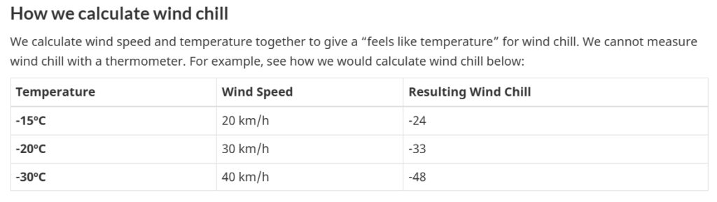
How wind chill is calculated by weather agencies
Wind chill is calculated using a standard formula created by weather scientists. Both Canada and the USA use a very similar modern formula today.
The calculation uses two main inputs
Air temperature
Wind speed
Humidity and sunshine are not included in the official wind chill formula. The focus is on how fast heat leaves exposed skin under wind flow.
Weather stations measure temperature and wind speed at a standard height above ground. Then they apply the formula to produce the wind chill value.
We do not need to solve the equation ourselves. Forecast systems handle that. But understanding the idea helps.
Example
Air temperature is minus 15 degrees
Wind speed is 30 km per hour
The wind chill value may come out near minus 27
That means our skin reacts like it is minus 27, not minus 15
Why wind speed changes how cold it feels
Wind speed plays a huge role in wind chill. Even a small increase in wind can make a big difference in how cold we feel.
Still air allows a warm layer to stay near our skin. Moving air removes it quickly.
Here is a simple way to picture it.
Example
Stand outside on a cold calm day. It feels cold but steady.
Now turn on a strong fan in that same cold air. It feels much colder right away.
That fan effect is similar to what outdoor wind does in winter weather.
Stronger wind equals faster heat loss. Faster heat loss equals lower feels like temperature.
Wind chill chart basics for daily use
Weather services often publish wind chill charts. These charts show how different wind speeds change the feels like temperature at different air readings.
You find air temperature on one side. Wind speed on the other hand. Where they meet shows the wind chill value.
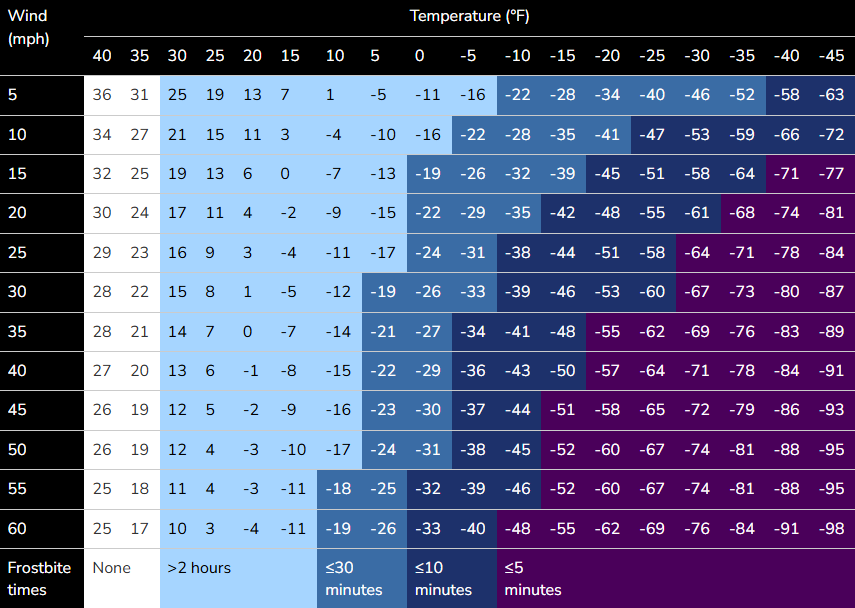
Image credits: noaa.gov
These charts help schools and safety officials make decisions about outdoor exposure. They are also used by construction crews and delivery services.
You do not need to memorize the chart. Just know that higher wind plus lower temperature creates more dangerous cold stress.
Wind chill vs actual temperature, key difference
Actual temperature measures the air itself. Wind chill measures the effect on our body.
Objects like car engines and water pipes respond mostly to actual temperature, not wind chill. But people and animals feel the wind chill effect strongly.
That means wind chill is about biological impact, not physical freezing point changes.
Example
Water freezes at zero degrees regardless of wind chill.
But our fingers can freeze faster in windy minus 10 than in calm minus 15.
So wind chill is about human safety, not chemistry.
How forecasts show wind chill in Canada and USA
Most modern weather apps and TV forecasts show wind chill automatically during cold months.
It may appear as
Feels like temperature
Real feel
Wind chill value
Morning forecasts often highlight it when values reach dangerous levels. Alerts may be issued when wind chill drops below specific thresholds.
Some school districts and workplaces use wind chill limits when deciding schedule changes. This is common in very cold regions.
Safety tips when wind chill is very low
When wind chill drops to severe levels, small actions make a big difference for our safety.
Wear layered clothing
Cover exposed skin
Use insulated gloves and hats
Limit time outdoors
Check on children and older adults
Face, ears, fingers, and toes are most at risk because they lose heat quickly.
Loose layers trap warm air better than one heavy tight layer. That helps reduce heat loss in windy conditions.
High wind chill safety tips, quick checklist for extreme cold days
When wind chill is very low, exposed skin can freeze in minutes and body heat drops quickly. Use this simple safety checklist to stay protected during extreme cold and strong wind.
- Dress in loose warm layers, inner layer, insulating layer, outer wind blocking layer
- Cover all exposed skin, wear hat, face cover, scarf, and mittens
- Choose mittens over gloves, they keep fingers warmer together
- Keep clothes and socks dry, wet fabric increases heat loss
- Limit time outdoors, delay non urgent trips and errands
- Stay indoors until pickup time for school or transit when possible
- Stand away from open wind, use buildings and barriers as shields
- Eat hot meals and drink warm fluids during the day
- Stay hydrated, good circulation helps protect fingers and toes
- Avoid alcohol, excess caffeine, and smoking, they reduce heat protection
- Keep moving lightly if outside, body movement creates heat
- Seal indoor drafts and keep living areas warm
- Check on seniors and people living alone daily
- Watch warning signs, numb skin, heavy shivering, confusion, slow thinking
- Seek medical help fast if body temperature drops or behaviour changes
- Carry winter gear in the car, blankets, extra gloves, hat, warm wrap
Small steps taken early help our body stay safer in dangerous wind chill conditions.
Quick recap
Wind chill explains how cold it feels on our skin when wind and low temperature combine. Basically It is calculated using air temperature and wind speed through a scientific formula used across Canada and the USA.
It does not change the actual air reading. It shows how fast our body loses heat. That makes it a key winter safety measure.
When we check winter forecasts, watching the wind adjusted cold value helps us plan clothing, travel, and outdoor time more wisely.
You have to use only an accurate snow day calculator to measure correct wind chill and snow days.
Also Read: How Schools Decide Snow Days and Closures Your Complete Guide
Resources:
https://www.noaa.gov/jetstream/synoptic/wind-chill
https://www.canada.ca/en/services/environment/weather/severeweather/wind-chill-index.html